Narrative and Photo Sequence of the Flood of 1948
(as observed at Hell's Gate)
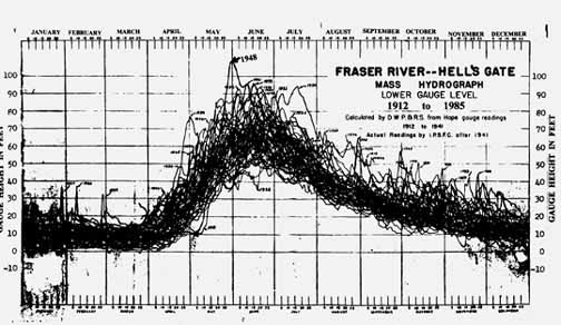
The annual peak run-off period of the Fraser River as observed at Hell’s Gate occurs normally in the period May to mid July. The spring run-off in an average year from most of the major tributaries of the Fraser System normally varies widely as to timing and volume, depending on depth of snow cover and local climatic conditions as the air temperatures in the spring increase.
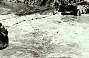
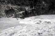
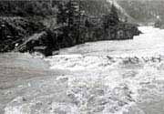
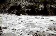
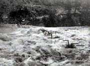
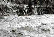
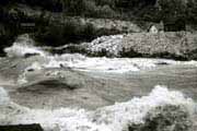
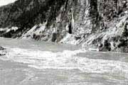
In 1948 however, with a substantial snow cover in the Fraser River watershed and very warm weather throughout the province, most streams experienced a rapid increase in discharge from mid May on. At the town of Lytton, about 25 miles upstream of Hell’s Gate, the Thompson River joins the Fraser River, and in 1948 the run-offs from these major watersheds coincided as to timing and intensity. The combined discharges of the Fraser and the Thompson down the Canyon and through Hell’s Gate reach in the last week of May 1948 proved to be the second largest recorded flow in the Fraser system.
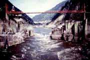
The flow as observed at Hell’s Gate peaked on May 30 at an estimated discharge of 537,000 cubic feet per second (cfs). Historic records indicate that the 1948 peak flow had been exceeded only once, in 1894 when the maximum Fraser River discharge had been estimated to be about 600,000 cfs. To put the 1948 flood volume in perspective, it is estimated that a continuous flow of 537,000 cubic feet per second would fill the dome-covered BC Place Stadium in Vancouver in less than two minutes.
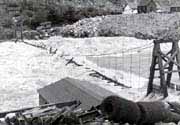
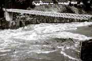
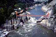
The fishways, built and completed in 1946, were inundated by more than 50 feet of water during the peak flow period in 1948. There was no visible damage to the fishway structures observed after the flood in spite of gravel, rocks and boulders, some as large as 2-3 feet in diameter as well as stumps, whole trees and logs that were carried down river by water flowing as fast as 40 mph. The original footbridge built by the International Pacific Salmon Fisheries Commission (IPSFC) for access to the west bank of the river prior to the construction of the first fishways in 1944 was completely destroyed in the 1948 flood.
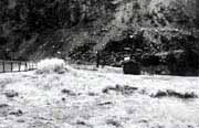
The Commission engineers designed and built a new suspension bridge at Hell’s Gate after the 1948 flood, completing the structure in 1949. This new bridge was designed to carry small vehicles and light construction equipment. Only a footpath from the Fraser Canyon Highway, now Highway #1, and down to the east abutment of the suspension bridge existed prior to 1957. Permanent IPSFC maintenance staff living in the camp on the west bank of the river had to carry their food and supplies down this steep footpath. A road for a 4-wheel drive vehicle was later carved out from the steep hillside and completed in 1959. At present time, no maintenance staff live permanently on site and the road access is only for foot traffic and official vehicles.
Access to the suspension bridge to view the fishways at Hell’s Gate can be had by hiking down a footpath from the Trans Canada Highway (Highway #1). The footpath starts at IPSFC‘s Monument adjacent to the highway above Hell's Gate. Alternate access is possible by a gondola from the upper terminal of the Hell's Gate Airtram located next to the highway a short distance north of the IPSFC Monument.
The following photos of the 1948 flood and the Mass Hydrograph are from the IPSFC Engineering Records prior to dissolution of the Commission in 1985 and computer enhanced by the author of this web site.